Close Alert Banner
Skip to Content

Kawartha Conservation Logo Kawartha Conservation Print Logo

Normal
Watershed Conditions Statement
Flood Watch
Flood Warning
Normal
Level I
Level II
Level III
  • Conservation Areas

    Conservation Areas

    • Durham East Cross Forest
    • Event Calendar
    • Fleetwood Creek
    • Ken Reid
    • Off-Leash Dog Park
    • Pigeon River Headwaters
    • Report an Issue
    • Windy Ridge
    • The Talking Forest
    • Kawartha Quest
    • Spring in the Kawartha Watershed
    • Disc Golf
    View our Durham East Cross Forest page
  • Permits and Planning

    Permits and Planning

    • Apply for a Permit
    • Book a Pre-Consultation Meeting
    • Event Calendar
    • Flood Plain Mapping
    • Planning Services
    • Property Information Requests
    • Property Mapping
    • Report a Violation
    • Source Protection Notice
    • Sediment and Erosion Control
    View our Property Mapping page
  • Landowner Services

    Landowner Services

    • Erosion and Shoreline Protection
    • Event Calendar
    • Farm Management
    • Healthy Gardens
    • Community Grants
    • Landowner Grants
    • Septic Systems and Wells
    • Tree Planting
    View our Tree Planting page
  • Learn and
    Get Involved

    Learn and Get Involved

    • Birding
    • Careers and Volunteering
    • Festivals
    • Citizen Science
    • Donations
    • Kawartha Conservation Foundation
    • Learn at Home
    • Nature Camps
    • News and Events
    • Professional Development
    • Students and Teachers
    • The Talking Forest
    • Spring time in the Kawartha Watershed
    • Kawartha Quest
    View our Kawartha Conservation Foundation page
  • Environmental Sciences

    Environmental Sciences

    • Climate Change
    • Data Requests and Maps
    • Drinking Water Source Protection
    • Flood Forecasting and Warning
    • Flood Plain Mapping
    • Lake and Environmental Management Plans
    • Lake Scugog Enhancement Project
    • Low Water and Droughts
    • Understanding your Watershed
    • Watershed Monitoring
    • Know Your Signs
    • Environmental Monitoring Strategy
    • Watershed Report Cards
    View our Cameron Lake page
  • About Us

    About Us

    • Accessibility
    • Board Meeting Calendar
    • Governance
    • Careers and Volunteering
    • Contact Us
    • Donations
    • Event Calendar
    • Online Store
    • Our Partners
    • Plans and Reports
    • Report an Issue
    • Who We Are
    • Bids and Tenders
    • Connect with Us Online
    View our Careers and Volunteering page
Contact Us

septic weeping system

Apply for a Permit

HomePermits and PlanningApply for a Permit
  • Open new window to share this page via Facebook Facebook
  • Open new window to share this page via Twitter Twitter
  • Open new window to share this page via Pinterest Pinterest
  • Open new window to share this page via LinkedIn LinkedIn
  • Email this page Email

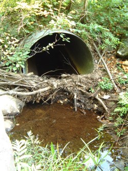
You will need a permit for any development that occurs within Kawartha Conservation's Regulated Area. Property mapping is available to help you determine if you require a permit. partially blocked culvert

Before submitting a permit application, you may want to book a pre-consultation meeting with one of our staff or submit a property information request. You can also review our frequently asked questions and submit your questions by email at any time.

For shoreline works please take a look at our Erosion and Shoreline Protection information before submitting a permit application.

Standard permit application

A standard permit is required for most projects within Kawartha Conservation's Regulated Area, however some minor projects qualify for the streamlined permit process.

Apply for a standard permit

You can also complete our permit application form and submit it by email or drop it off at our office. Completed permit application forms can be dropped off at:

277 Kenrei (Park) Road
Lindsay, ON K9V 4R1

If paying by cheque, make payable to: Kawartha Conservation

Application requirements

Your application must include:

  • A copy of the deed or tax bill to prove ownership
  • A registered plan/survey (if available)
  • Location map showing nearest intersections (e.g. Google map)
  • Detailed letter/report describing the proposal
  • Volume and origin of any fill material from an off-site source for septic systems, driveways, foundations, etc.
  • One set of plans/drawings (paper copies must be no larger than 11" x 17")
  • Signed letter of authorization from the owner to applicant (if applicant is not owner)
  • Statement of agreement from any persons sharing right-of-ways, easements, etc. (if applicable)
  • Colour photographs of entire shoreline taken in summer (if shoreline works or boathouse proposed)
  • Sediment and erosion control proposal (for infrastructure, commercial/industrial/multi-residential)

Additional application requirements can include the following, depending on the features present on your property:

  • Environmental impact study
  • Wetland compensation plan
  • Elevation/topographic survey
  • Geotechnical and/or slope stability study
  • Engineered drawings
  • Floodplain modelling/mapping
  • Stream bank erosion analysis
  • Geomorphologic assessment
  • Etc.

Wait times

Standard permit applications are reviewed within 14 days of being received.  Your application will then be deemed "Complete" or "Incomplete".

If your application has been deemed "Incomplete" then we will contact you to let you know what information is missing.

A permit will be issued within 21 days from the date your application has been deemed "Complete".

Expiry

Standard permits expire two years after they are issued

Streamlined permit application

Certain projects are eligible for the streamlined application process. For a streamlined approval, you are required to submit a completed application along with one set of plans/drawings.

Apply for a streamlined permit

You can also complete our streamlined permit application form and submit it by email or drop it off at our office. Completed permit application forms can be dropped off at:

277 Kenrei (Park) Road
Lindsay, ON K9V 4R1

Eligibility

Only relatively minor projects qualify for a streamlined permit application. Examples include:

  • Construction of non-habitable accessory buildings or structures that are less than 46.5 square metres in size, located outside of any wetland
  • Installation of swimming pools, located outside of any wetland and/or flooding hazard
  • Construction of unenclosed decks, patios
  • Construction of single residential docks where fill placement, excavation and/or grade modifications are required
  • Roadside ditch maintenance
  • Routine maintenance and/or repair of public/private infrastructure
  • Culvert replacements of the same length and diameter
  • Fill placement, excavation, and/or grade modifications with volume not exceeding 20 cubic metres outside of any wetland or watercourse
  • Maintenance of existing dug-out or isolated ponds
  • Replacement of existing septic systems in the same location, outside of any flooding hazard

Wait times

Streamlined permit applications are usually reviewed and a permit is issued within 14 days of being received. If any information is missing, then we will contact you. 

Expiry

Streamlined permits expire one year after they are issued

Fees

You must pay a fee for all permit applications.

Application fees vary based on the type of development proposed.

Payment is required prior to any permit approvals and can be paid by cheque, credit card, debit, cash or e-transfer.

Picking up your permit

All permits will be issued via email unless specified otherwise.

If you wish to pick up a paper copy of your permit please indicate this in your application. The owner or applicant listed on the permit application must come in and sign the permit. The owner or applicant will be provided with two copies of the permit, one for their own records, and one that can be submitted to the applicable Municipality's Building Department if a Building Permit is required.

Permits can be picked up from our office located at:

277 Kenrei (Park) Road
Lindsay, Ontario  K9V 4R1

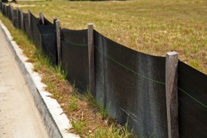
silt fencing

Erosion and sediment control

Erosion and sediment control is an important part of many of the permits issued by Kawartha Conservation. To find our more about some simple and effective ESC measures please go to our Erosion and Sediment Control page.

Regulation policies

You can find more information on Kawartha Conservation's permit policies in Chapter 4 of our Plan Review and Regulation Policies.

Frequently asked questions

What is considered “development”?
Development includes (but is not limited to) the following:
  • Fill placement, grade modifications and/or excavation. Fill includes sand, gravel, soil, rock, etc.
  • Construction or demolition of a structure (e.g. house, garage, shed, storage building, etc.) or additions to existing structures
  • Shoreline works, including installation of a new stone wall
  • Installation of utilities, such as natural gas pipelines, waterlines, etc.
  • Construction of a deck or gazebo
  • Installation or replacement of culverts, bridges, water control structures, etc.
  • Realignment or channelization of any waterway
  • Dredging of any waterway
  • Creation or removal of ponds
Do I need a permit from any other government institution?

If you need a permit from Kawartha Conservation, then you most likely will need a permit from your local municipality. You may also need a permit from Parks Canada if you are conducting any shoreline/in-water works along the Trent Severn Waterway.

You may also need a permit from the Department of Fisheries and Oceans (DFO) or the Ontario Ministry of Natural Resources and Forestry (MNRF).

It is your responsibility to determine all permitting requirements before beginning work.

Why is my property regulated by Kawartha Conservation?

Kawartha Conservation regulates the following areas:

  • River or stream valleys (including lakes);
  • Wetlands and buffers (“Areas of Interference”) surrounding wetlands;
  • Hazardous lands (including flooding and erosion hazard areas, and unstable soil or bedrock); and
  • Rivers, creeks, streams or watercourses.
What should I do if I need help?

Please contact us if you have questions about permit application requirements, policies, etc.  We can answer most questions via phone or email.

We also offer free in-person pre-consultation meetings every Tuesday at our Administrative Centre in Lindsay. These meetings will help you through the permitting process, our policies, and permit application requirements.

How do I find out what planning or permitting restrictions may apply before buying a property?

Please submit a Property Information Request. We will review the property and identify what regulated features are present on the property (e.g. wetlands, watercourses, etc.). A letter will be sent to you with the information needed to get a permit and any restrictions that may apply.

Please note that a Property Information Request is not a permit and is not permission to start construction.

What kind of rules apply to building a boathouse?

All new or replacement boathouses within the flood plain must be no larger than 80 square metres and can only be a single-storey. The boathouse must also remain uninsulated and all electrical outlets must be raised above the flood plain. No plumbing or heating is permitted.

Do I need a permit to remove trees from my property?

A permit is only required if you need to excavate the roots of the tree(s) or the area where the tree(s) will be removed is wetland.

Excavation of tree roots outside of Kawartha Conservation's Regulated Area does not require a permit. Property Mapping is available to help you determine if your property falls within a Regulated Area.

Do I need a permit to install a fence?

Usually, no permits are required to install a new fence. 

A permit may be required if there will be direct impacts to a watercourse or wetland. For example, you would like to install a fence directly through a wetland or across a watercourse.

I would like to restore/protect my shoreline, what is permitted?

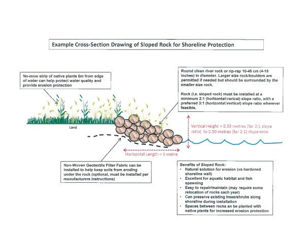
Installation of sloped rock along shorelines is often the best option to stabilize soil and protect property, while maintaining and enhancing water quality and aquatic habitat. An example cross-section of a sloped rock wall can be seen below:

Example sloped rock cross-section

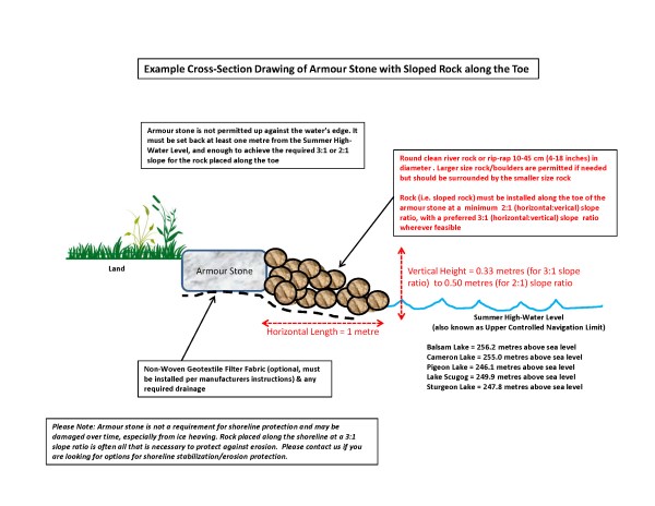
Vertical shoreline retaining walls (e.g., armour stone) are not permitted. Armour stone (or similar) can be installed upland, approximately 1 metre from the normal high-water mark, with sloped rock placed along the toe to act as the interface between land and water. An example of an acceptable armour stone / sloped rock shoreline retaining wall can be seen below:

 Example armour stone with sloped rock cross-section

For more information check out our Erosion and Shoreline Protection webpage

Permits and Planning
    • Apply for a Permit
    • Book a Pre-Consultation Meeting
    • Event Calendar
    • Flood Plain Mapping
    • Planning Services
    • Property Information Requests
    • Property Mapping
    • Report a Violation
    • Source Protection Notice
    • Sediment and Erosion Control

Contact Us

Subscribe to this page
  • Report an Issue
  • Accessibility
  • Careers
  • Store
  • Contact Us

Kawartha Conservation Footer Logo

© 2020 Kawartha Conservation

  • Freedom of Information
  • Privacy Policy
  • Sitemap
  • Website Feedback

Follow Us

View our Facebook Page View our Twitter Page View our Instagram Page View our YouTube Page View our LinkedIn Page

Immigration, Refugees and Citizenship Canada logo

With the support of the Government of Canada through the Federal Economic Development Agency for Southern Ontario

Designed by eSolutionsGroup

Close Old Browser Notification
Browser Compatibility Notification
It appears you are trying to access this site using an outdated browser. As a result, parts of the site may not function properly for you. We recommend updating your browser to its most recent version at your earliest convenience.