Understanding the land we protect, and why it matters
What is the Kawartha Conservation Watershed?
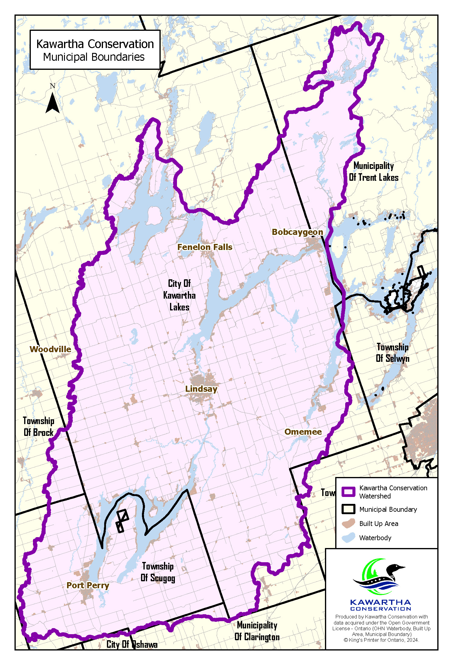
When people hear the term ‘Kawartha Conservation,’ they often associate our work with the boundaries of the City of Kawartha Lakes. And while we’re proud to serve this vibrant municipality, the area we steward, our watershed, is determined by nature, not political lines.
A watershed is an area of land where all the water that falls on it, whether from rain, snow, or runoff, drains into a common water body, such as a river, lake, or wetland. Watersheds are defined by topography. That means water flows downhill, across forests, fields, roads, and communities, eventually collecting in streams and lakes - no matter what political boundary it crosses along the way.
“A watershed is nature’s way of organizing the landscape,” explains Nancy Aspden, Director of Integrated Watershed Management at Kawartha Conservation. “It’s how water moves, across municipal lines, through forests, wetlands, and neighborhoods, ultimately connecting us all.”
Kawartha Conservation’s watershed includes not only the majority of the City of Kawartha Lakes, but also portions of the Municipality of Trent Lakes, Township of Scugog, the Municipality of Clarington, and the Townships of Brock and Cavan Monaghan. This area spans nearly 2,600 square kilometres and includes more than 250 lakes, rivers, and wetlands, draining primarily into the Scugog River, Pigeon River, and Lakes Scugog, Pigeon, Cameron, Balsam and Sturgeon.
Most of the water in this region originates as precipitation - rain and snow falling across the diverse landscape of upland forests, farmlands, and wetlands. It also enters the system from groundwater sources, feeding springs and streams from below the surface. Key headwaters, for the majority of lakes in the
Kawartha watershed, start in the north, through the Burnt and Gull River systems. Headwaters near the Oak Ridges Moraine, travels across the land through tributaries, wetlands, and lakes before converging into major rivers.
Water flows east through Pigeon Lake, and then ultimately, that water flows east and south, joining the Otonabee and Trent Rivers before emptying into the Bay of Quinte, and then Lake Ontario. The Kawartha watershed is part of the larger Great Lakes Basin, meaning water that starts here influences the health of aquatic ecosystems far beyond our borders.
“It’s a massive connected system,” says Brett Tregunno, Aquatic Biologist with Kawartha Conservation. “A raindrop falling in a farmer’s field near Bethany could eventually make its way to Lake Ontario. That’s why every action we take across the watershed matters.”
“People are often surprised that our work stretches beyond Kawartha Lakes,” adds Tregunno. “But water doesn’t stop at a township line. What happens upstream, whether it's development, land use, or pollution, can have a big impact downstream. That’s why managing from a watershed perspective is so critical.”
Watershed-based management means looking at the entire connected system, rather than just a small piece of it. This is especially important when it comes to things like water quality, stormwater, erosion, habitat protection, and land-use planning.
“If you manage land and water based only on municipal lines, you risk missing the big picture,” adds Aspden. “For example, a subdivision in one township could lead to increased flooding in another if water isn’t properly managed. That’s where we come in - to ensure development, restoration, and planning decisions work for the watershed as a whole.”
Healthy watersheds are also a key part of climate resilience. Natural systems like forests, wetlands, and shoreline buffers help absorb stormwater, filter pollutants, and slow the flow of runoff during major rain events.
“We’re seeing more extreme weather and unpredictable seasons,” says Tregunno. “Maintaining forests, wetlands, and other wild spaces across the watershed is one of the best tools we have to reduce the impacts of flooding, protect drinking water, and safeguard wildlife habitat.”
At Kawartha Conservation, everything we do - from monitoring water quality to reviewing planning applications, from supporting farmers to restoring shorelines - is guided by the principle that we are all connected by water.
“When you understand how a watershed works, you realize we all live downstream from someone,” says Aspden. “Protecting the health of our water means working together, across boundaries, to make decisions that support the entire system, now and for future generations.”
Contact Us
Kawartha Conservation
277 Kenrei Road
Lindsay, ON K9V 4R1
Tel: 705.328.2271
Fax: 705.328.2286
Subscribe to Receive Updates and Notifications
Stay up to date on flood and low water, news, activities, events, programs and operations by subscribing to updates and the Watershed Watch Newsletter.