Lake Health Monitoring Program - Balsam Lake
ABOUT THE LAKE
A remarkable lake at the top of the system
Balsam Lake is located at the northern end of the City of Kawartha Lakes, adjacent to the community of Coboconk, and is the highest-elevation lake on the Trent-Severn Waterway system. With a surface area of approximately 48 km², it is the largest lake located entirely within the City of Kawartha Lakes, and the fourth largest lake within the Trent-Severn Waterway system.
The lake is an important ecological, recreational and economic resource, supporting waterfront living, boating, swimming, fishing, tourism and other community uses.
Lake surface area
48 km²
Balsam Lake watershed
115 km²
Lake on the Trent-Severn Waterway
Highest
MONITORING CYCLE
Three perspectives. One clearer picture.
Lake health is not defined by a single measurement. Water quality, aquatic plants and shoreline conditions are monitored over a five-year cycle to show how the lake and its watershed are changing.
Balsam Lake is monitored every two years as part of Kawartha Conservation’s bi-annual Lake Health Monitoring Program. The program brings together information from three areas: water quality and vertical lake profiling, aquatic plants, and shoreline condition. Staff monitor nutrients and other water-quality indicators, measure temperature and dissolved oxygen from the surface to the lake bottom, survey aquatic plant species and abundance, and assess natural and altered shoreline areas. Looking at these indicators together provides a more complete understanding of the lake, helps track changes over time, and informs decisions that support its long-term health.
The current StoryMap presents the results of 2025 water quality monitoring conducted at three locations on Balsam Lake and three tributary locations within the surrounding watershed. It shows that Balsam Lake continues to have generally good water quality, while identifying phosphorus as an ongoing concern and noting localized phosphorus and dissolved oxygen concerns in some tributaries. The StoryMap also explains how future aquatic plant and shoreline monitoring will add to this understanding, with aquatic plants scheduled to be sampled in 2027 and shoreline conditions in 2028.
2025 | Results available
Water quality
Tracks phosphorus, chloride, dissolved oxygen and other indicators at lake and tributary monitoring stations.
2027 | Scheduled
Aquatic plants
Measures aquatic plant coverage, the presence of invasive plants and the maximum depth of plant growth.
2028 | Scheduled
Shoreline conditions
Assesses natural plant cover, woody structure and overhanging vegetation around the lake.
See what the monitoring tells us
Explore maps, plain-language findings and downloadable water-quality data for Balsam Lake and its tributaries.
FROM PLAN TO PROGRESS
Five priorities for a healthy Balsam Lake
The Balsam Lake and Cameron Lake Management Plan provides the long-term direction. Monitoring helps show whether lake conditions are improving, holding steady or facing new pressures.
01
Maintain excellent water quality
Reduce nutrient and contaminant inputs from runoff, agricultural lands and shoreline septic systems.
Monitoring signal
Phosphorus, chloride and dissolved oxygen trends.
02
Protect and restore natural shorelines
Restore shoreline vegetation, reduce shoreline hardening and protect nearshore habitat.
Monitoring signal
Plant cover, woody structure and overhanging vegetation.
03
Conserve biodiversity
Protect aquatic habitat and help prevent the spread of invasive species.
Monitoring signal
Plant coverage, invasive plants and depth of plant growth.
04
Support sustainable development
Use strong planning policies and responsible infrastructure practices to protect lake and watershed health.
Monitoring signal
Long-term environmental trends and areas showing increased pressure.
05
Increase stewardship and involvement
Give residents, lake users and community partners the information needed to take meaningful action.
Monitoring signal
Clear, accessible findings that guide local decisions and stewardship activities.
Want the full picture?
Read the complete Balsam Lake and Cameron Lake Management Plan.
ABOUT THE WATERSHED
Healthy lands support a healthy lake
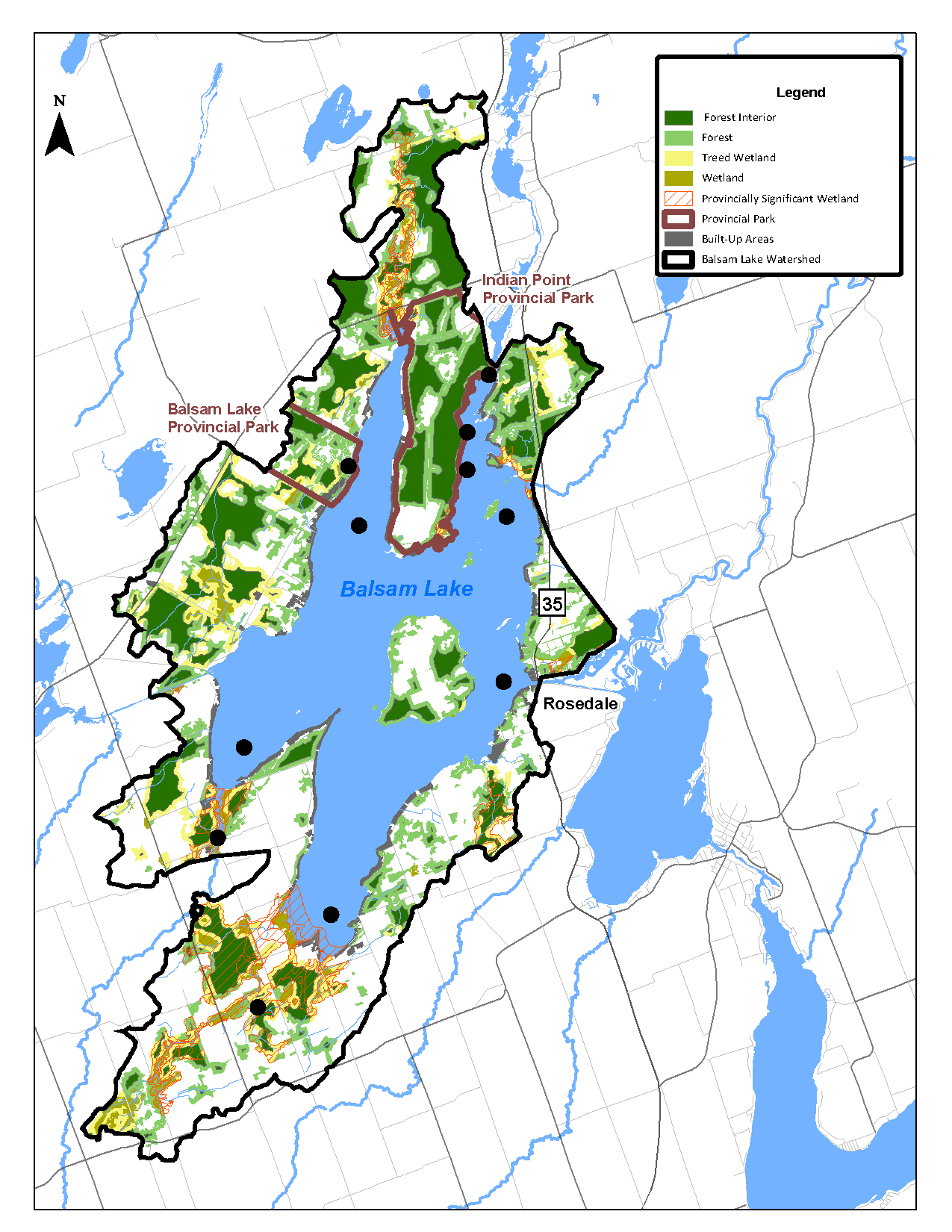
The Balsam Lake watershed covers approximately 115 km² and consists of a diverse landscape of forests, wetlands and other natural features.
It includes several Provincially Significant Wetlands, including Balsam Lake South Bay No. 42 and Indian Point. These areas provide important habitat for a wide variety of plant and animal species and contribute to the watershed’s overall ecological health.
Why monitor the watershed as well as the lake?
A lake reflects what happens across its entire watershed. Water flowing over the surrounding landscape can carry nutrients, sediment and contaminants into streams and, ultimately, the lake. Monitoring both the lake and its watershed helps identify changing conditions, understand potential sources of stress and support informed management decisions.
Explore another lake
Explore monitoring findings for the other lakes included in Kawartha Conservation’s Lake Health Monitoring Program.
Contact Us
Kawartha Conservation
277 Kenrei Road
Lindsay, ON K9V 4R1
Tel: 705.328.2271
Fax: 705.328.2286
Subscribe to Receive Updates and Notifications
Stay up to date on flood and low water, news, activities, events, programs and operations by subscribing to updates and the Watershed Watch Newsletter.