
Lake Health Monitoring Program - Sturgeon Lake
ABOUT THE LAKE
A central lake connecting waterways, wetlands and communities
Sturgeon Lake is monitored every two years as part of Kawartha Conservation’s bi-annual Lake Health Monitoring Program. The program brings together information from three areas: water quality and vertical lake profiling, aquatic plants, and shoreline condition.
Staff monitor nutrients and other water-quality indicators, measure temperature and dissolved oxygen from the surface to the lake bottom, survey aquatic plant species and abundance, and assess natural and altered shoreline areas. Looking at these indicators together provides a more complete understanding of the lake, helps track changes over time, and informs decisions that support its long-term health.
The current StoryMap presents the results of 2025 water quality monitoring conducted at three locations on Sturgeon Lake and five tributary locations within the surrounding watershed. It shows that Sturgeon Lake continues to have generally good water quality, with no significant water-quality concerns identified. Water quality in the monitored tributaries has also improved for dissolved oxygen, phosphorus and aluminum. Chloride, which is commonly associated with winter road salt, has been identified as an emerging concern in the tributaries.
The StoryMap also presents the first lake-wide aquatic plant survey of Sturgeon Lake. Aquatic plants were sampled at 478 locations in July 2025. Shoreline monitoring is also underway, with aerial imagery analysis completed and boat-based surveys continuing in 2026.
Lake area
46 km²
Watershed Area
144 km²
Natural vegetation cover
33%
MONITORING CYCLE
Three perspectives. One clearer picture.
Sturgeon Lake is a large, interconnected lake extending between Lindsay, Fenelon Falls and Bobcaygeon. Its size, varied shoreline, tributaries and connections with neighbouring lakes make coordinated monitoring important for understanding how conditions differ across the lake and its surrounding watershed.
Sturgeon Lake is monitored every two years as part of Kawartha Conservation’s Lake Health Monitoring Program. Staff examine water quality and conditions at different depths, survey aquatic plant communities, and assess the amount and quality of natural shoreline habitat. Monitoring across these three areas helps determine whether existing conditions are being maintained, identify emerging concerns such as rising chloride levels, and provide information that can guide shoreline stewardship and watershed-management decisions.
The current StoryMap presents the results of 2025 water-quality monitoring conducted at three locations on Sturgeon Lake and five stream locations within the surrounding watershed. Sturgeon Lake continues to have generally good water quality, with no significant concerns identified in the lake. Conditions in its tributaries have also improved for dissolved oxygen, phosphorus and aluminum, although chloride from winter salt use is emerging as an area to watch. Aquatic plants were surveyed at 478 locations and were found across approximately 40 per cent of the lake, including a moderate presence of sensitive species. Invasive plants, including Eurasian Watermilfoil and Starry Stonewort, were found at 57 per cent of locations where plants were present. Shoreline imagery shows that natural plant cover decreased slightly between 2008 and 2023, while additional shoreline survey results will provide a more complete assessment of current conditions.
2025 | Results available
Water quality
Tracks phosphorus, chloride, dissolved oxygen and other indicators at three lake stations and five tributary monitoring stations.
2025 | Results available
Aquatic plants
Examines plant coverage, invasive species and the depth at which aquatic plants are growing across the lake.
2026 | Monitoring Underway
Shoreline conditions
Measures natural plant cover, woody habitat and overhanging vegetation along the Sturgeon Lake shoreline.
See what the monitoring tells us
Monitoring Sturgeon Lake brings together information about the water, the aquatic plant community and the shoreline. Each area provides a different perspective on lake health, while repeated monitoring helps identify meaningful changes over time.
FROM PLAN TO PROGRESS
Five priorities for a healthy Sturgeon Lake
The Sturgeon Lake Management Plan identifies five strategic themes that connect scientific monitoring with practical action. Monitoring helps show whether lake conditions are improving, holding steady or facing new pressures.
01
Support stewardship
Help rural landowners, urban and shoreline residents, and lake users undertake projects and adopt practices that benefit the lake.
Monitoring signal
Water-quality and shoreline results help identify where natural buffers, stormwater controls, septic improvements and shoreline restoration can have the greatest effect.
02
Strengthen planning
Use land-use policies, development standards and coordinated permitting to protect shorelines, streams, natural areas and water quality.
Monitoring signal
Changes in shoreline plant cover and tributary water quality help show how development and surrounding land use may be affecting the lake.
03
Improve infrastructure
Manage stormwater, wastewater, roads, municipal drains, construction activities and public waterfront areas in ways that reduce pollution and protect the lake.
Monitoring signal
Chloride, phosphorus, sediment and other water-quality indicators help identify pressures associated with runoff and infrastructure.
04
Continue research and monitoring
Track key indicators and investigate how Sturgeon Lake is responding to development, climate change, invasive species and other emerging pressures.
Monitoring signal
Repeated water-quality, aquatic plant and shoreline surveys provide the evidence needed to identify changes and evaluate the effectiveness of management actions.
05
Grow communication and collaboration
Share scientific findings, support community participation and encourage a shared responsibility for the health of Sturgeon Lake.
Monitoring signal
Accessible results help residents, lake associations, municipalities and other partners understand conditions and make informed decisions.
Want the full picture?
Explore the Sturgeon Lake Management Plan to learn more about its objectives, targets and recommended actions.
ABOUT THE WATERSHED
Healthy lands support a healthy lake
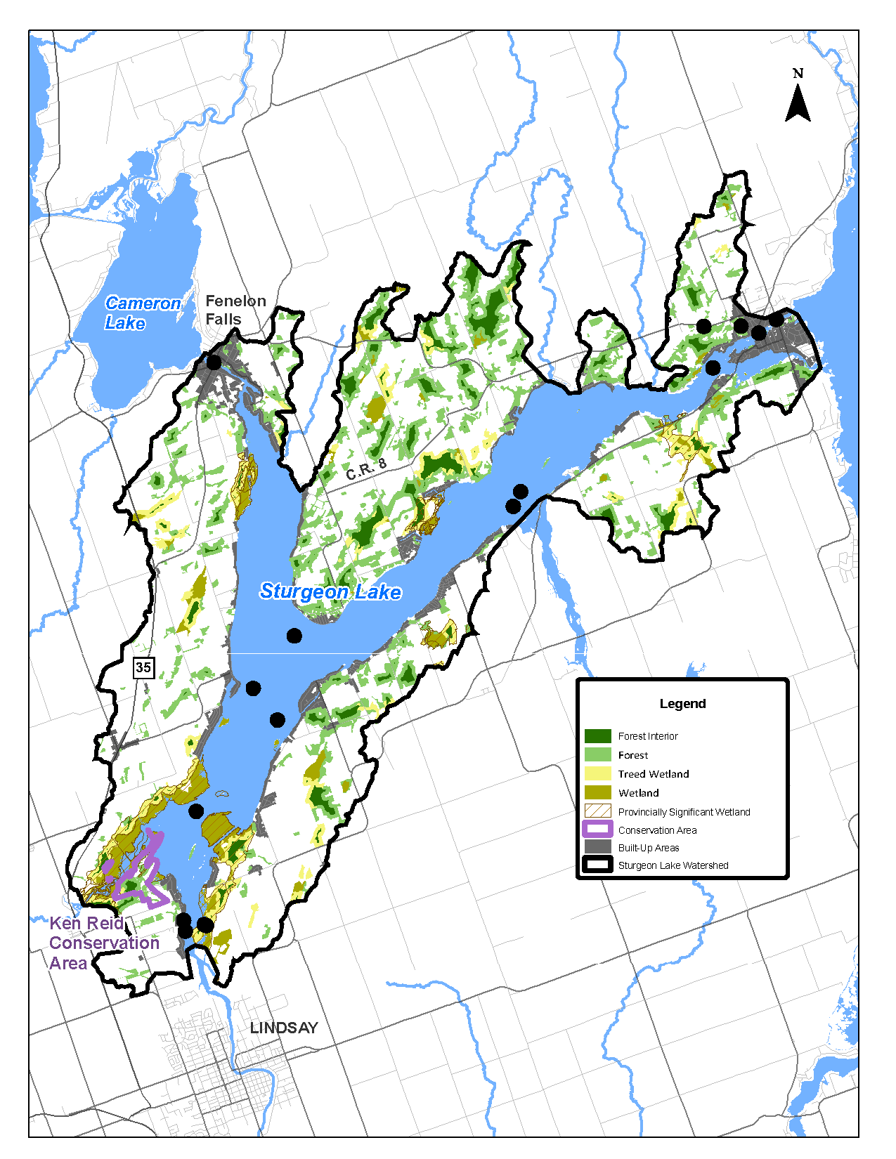
The Sturgeon Lake watershed covers approximately 144 km² and includes a diverse landscape of forests, wetlands, agricultural lands, communities and other natural features.
It includes several Provincially Significant Wetlands, including Anstonia and Sandy Point, Ellery Bay, Emily Creek No. 2, Nogies Creek Mouth and the Sturgeon Lake No. 26 and No. 27 wetlands. These areas provide important habitat for plants and animals, help store and filter water, and contribute to the watershed’s overall ecological health.
Why monitor the watershed as well as the lake?
A lake reflects what happens across its entire watershed. Water flowing over the surrounding landscape can carry nutrients, sediment, road salt and other contaminants into tributaries such as Emily Creek, McLarens Creek, Hawkers Creek and Martin Creek, and ultimately into Sturgeon Lake.
Sturgeon Lake is also influenced by water arriving from the Scugog River and Cameron Lake. Monitoring the lake and the surrounding watershed helps identify changing conditions, understand potential sources of stress and support informed management decisions across this connected system.
Explore another lake
Explore monitoring findings for the other lakes included in Kawartha Conservation’s Lake Health Monitoring Program.
Contact Us
Kawartha Conservation
277 Kenrei Road
Lindsay, ON K9V 4R1
Tel: 705.328.2271
Fax: 705.328.2286
Subscribe to Receive Updates and Notifications
Stay up to date on flood and low water, news, activities, events, programs and operations by subscribing to updates and the Watershed Watch Newsletter.