
Lake Health Monitoring Program - Cameron Lake
ABOUT THE LAKE
Where rivers, lakes and communities connect
Cameron Lake is a relatively compact but highly connected lake situated between Balsam Lake and Sturgeon Lake. It receives water from Balsam Lake through the Rosedale River and from the Canadian Shield through the Burnt River. Water leaves the lake at Fenelon Falls and continues into Sturgeon Lake.
These connections mean that Cameron Lake reflects conditions across a much larger landscape. Water entering from surrounding rivers, tributaries and developed areas can carry nutrients, sediment and other materials into the lake. Monitoring Cameron Lake helps identify changing conditions, understand potential sources of stress and support informed decisions throughout this connected system.
This eliminates the monitoring details from the opening and gives visitors a meaningful introduction to Cameron Lake itself.
Lake area
14 km²
Watershed Area
26 km²
Natural vegetation cover
31%
MONITORING CYCLE
Three perspectives. One clearer picture.
Lake health is not defined by a single measurement. Water quality, aquatic plants and shoreline conditions are monitored over a five-year cycle to show how Cameron Lake and its surrounding watershed are changing.
Cameron Lake is monitored every two years as part of Kawartha Conservation’s bi-annual Lake Health Monitoring Program. Staff monitor nutrients and other water-quality indicators, measure temperature and dissolved oxygen from the surface to the lake bottom, survey aquatic plant species and abundance, and assess natural and altered shoreline areas.
The current StoryMap presents the results of 2025 water-quality monitoring conducted at three locations on Cameron Lake and two tributary locations. Most water-quality indicators remain in good condition, although phosphorus has declined from fair to poor since the development of the Lake Management Plan. Localized phosphorus, dissolved oxygen and turbidity concerns were also identified in some tributaries.
Aquatic plants will be surveyed in 2027, followed by shoreline monitoring in 2028. Together, these results will provide a more complete picture of conditions across Cameron Lake.
2025 | Results available
Water quality
Tracks phosphorus, chloride, dissolved oxygen and other indicators at three lake stations and two tributary monitoring stations.
2027 | Scheduled
Aquatic plants
Will examine plant coverage, invasive species and the depth at which aquatic plants are growing across Cameron Lake.
2028 | Scheduled
Shoreline conditions
Will measure natural plant cover, woody habitat and overhanging vegetation along the Cameron Lake shoreline.
See what the monitoring tells us
The current results provide an updated look at water quality in Cameron Lake and the tributaries that flow into it. Future aquatic plant and shoreline surveys will add new layers of information and help build a more complete picture of lake health.
FROM PLAN TO PROGRESS
Five priorities for a healthy Cameron Lake
The Balsam and Cameron Lake Management Plan identifies five strategic themes that connect scientific monitoring with practical action. Monitoring helps show whether lake conditions are improving, holding steady or facing new pressures.
01
Maintain excellent water quality
Protect water quality in Cameron Lake and its tributaries for ecological health, recreation and other community uses.
Monitoring signal
Phosphorus, dissolved oxygen, turbidity and other indicators help identify changes in the lake and potential sources of stress within the watershed.
02
Protect natural shorelines
Maintain and restore shoreline vegetation that filters runoff, reduces erosion and provides habitat for fish and wildlife.
Monitoring signal
Future surveys will measure natural plant cover, woody structure and overhanging vegetation along the Cameron Lake shoreline.
03
Conserve biodiversity
Protect native plants, fish, wildlife and the habitats they need while reducing the spread and effects of invasive species.
Monitoring signal
Aquatic plant surveys will document plant diversity, sensitive species, invasive plants and the extent of plant growth across the lake.
04
Support sustainable development
Guide development, infrastructure and land-use decisions in ways that protect natural features and reduce impacts on the lake.
Monitoring signal
Tributary and lake-water results help show how stormwater runoff, surrounding land use and other watershed activities may be influencing Cameron Lake.
05
Grow stewardship and involvement
Support residents, lake users, municipalities and community organizations in taking practical action to protect the lake.
Monitoring signal
Accessible monitoring results help the community understand lake conditions, identify emerging concerns and focus stewardship activities where they can have the greatest effect.
Want the full picture?
Explore the Balsam Lake and Cameron Lake Management Plan to learn more about its objectives, targets and recommended actions.
ABOUT THE WATERSHED
Healthy lands support a healthy lake
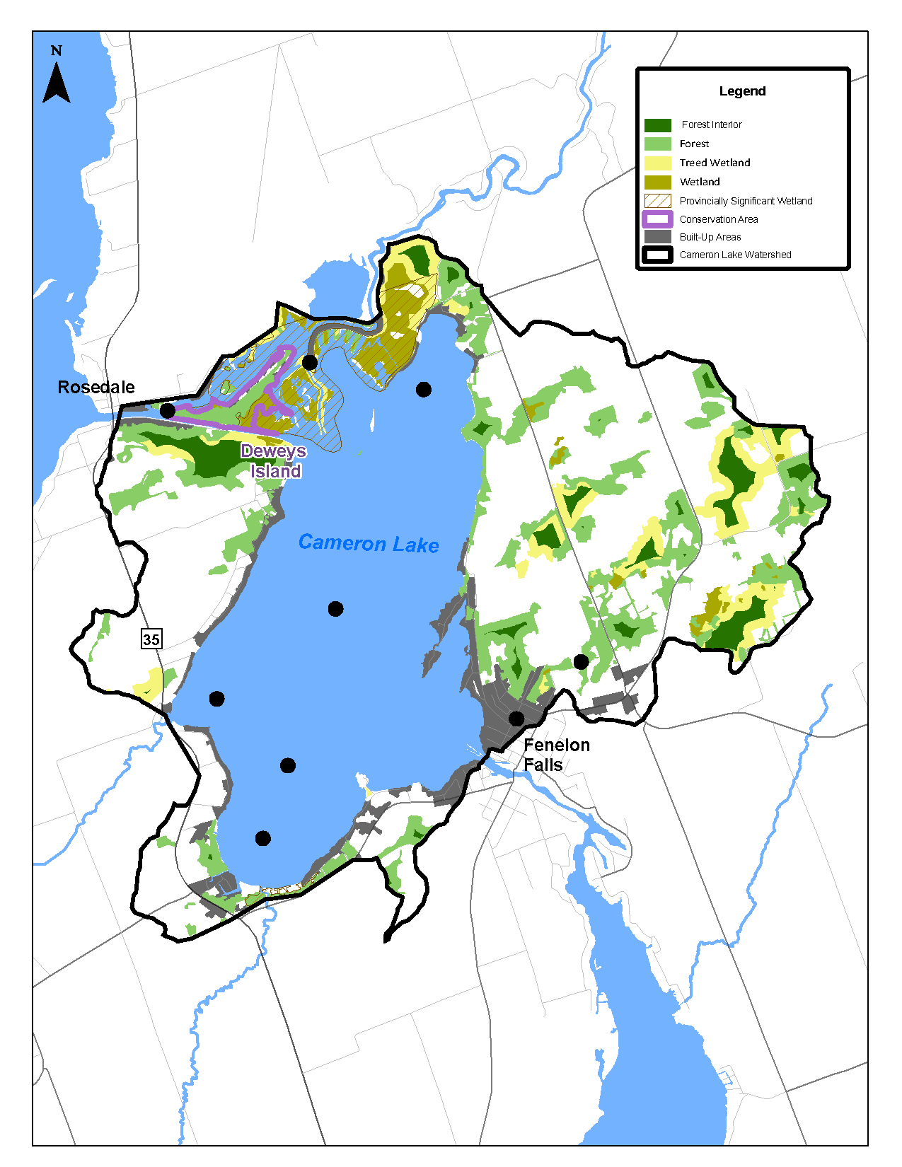
The Cameron Lake watershed covers approximately 26 km² and consists of a diverse landscape of mixed forests, wetlands and other natural features.
It includes several Provincially Significant Wetlands, including Balsam Lake 15, Cameron Lake No. 6 and Pearns Creek. The Burnt River Mouth Wetlands are also recognized as an Area of Natural and Scientific Interest. These areas provide important habitat for a wide variety of plant and animal species and contribute to the watershed’s overall ecological health.
Why monitor the watershed as well as the lake?
A lake reflects what happens across its entire watershed. Water flowing over the surrounding landscape can carry nutrients, sediment and contaminants into creeks and rivers and, ultimately, the lake.
Cameron Lake also receives water from Balsam Lake through the Rosedale River and from the Canadian Shield through the Burnt River. Water then leaves Cameron Lake at Fenelon Falls and flows into Sturgeon Lake. Monitoring the lake and its surrounding watershed helps identify changing conditions, understand potential sources of stress and support informed management decisions across this connected system.
Explore another lake
Explore monitoring findings for the other lakes included in Kawartha Conservation’s Lake Health Monitoring Program.
Contact Us
Kawartha Conservation
277 Kenrei Road
Lindsay, ON K9V 4R1
Tel: 705.328.2271
Fax: 705.328.2286
Subscribe to Receive Updates and Notifications
Stay up to date on flood and low water, news, activities, events, programs and operations by subscribing to updates and the Watershed Watch Newsletter.