Close Alert Banner
Skip to Content

Kawartha Conservation Logo Kawartha Conservation Print Logo

Normal
Watershed Conditions Statement
Flood Watch
Flood Warning
Normal
Level I
Level II
Level III
  • Conservation Areas

    Conservation Areas

    • Durham East Cross Forest
    • Event Calendar
    • Fleetwood Creek
    • Ken Reid
    • Off-Leash Dog Park
    • Pigeon River Headwaters
    • Report an Issue
    • Windy Ridge
    • The Talking Forest
    • Kawartha Quest
    • Spring in the Kawartha Watershed
    • Disc Golf
    View our Durham East Cross Forest page
  • Permits and Planning

    Permits and Planning

    • Apply for a Permit
    • Book a Pre-Consultation Meeting
    • Event Calendar
    • Flood Plain Mapping
    • Planning Services
    • Property Information Requests
    • Property Mapping
    • Report a Violation
    • Source Protection Notice
    • Sediment and Erosion Control
    View our Property Mapping page
  • Landowner Services

    Landowner Services

    • Erosion and Shoreline Protection
    • Event Calendar
    • Farm Management
    • Healthy Gardens
    • Community Grants
    • Landowner Grants
    • Septic Systems and Wells
    • Tree Planting
    View our Tree Planting page
  • Learn and
    Get Involved

    Learn and Get Involved

    • Birding
    • Careers and Volunteering
    • Festivals
    • Citizen Science
    • Donations
    • Kawartha Conservation Foundation
    • Learn at Home
    • Nature Camps
    • News and Events
    • Professional Development
    • Students and Teachers
    • The Talking Forest
    • Spring time in the Kawartha Watershed
    • Kawartha Quest
    View our Kawartha Conservation Foundation page
  • Environmental Sciences

    Environmental Sciences

    • Climate Change
    • Data Requests and Maps
    • Drinking Water Source Protection
    • Flood Forecasting and Warning
    • Flood Plain Mapping
    • Lake and Environmental Management Plans
    • Lake Scugog Enhancement Project
    • Low Water and Droughts
    • Understanding your Watershed
    • Watershed Monitoring
    • Know Your Signs
    • Environmental Monitoring Strategy
    • Watershed Report Cards
    View our Cameron Lake page
  • About Us

    About Us

    • Accessibility
    • Board Meeting Calendar
    • Governance
    • Careers and Volunteering
    • Contact Us
    • Donations
    • Event Calendar
    • Online Store
    • Our Partners
    • Plans and Reports
    • Report an Issue
    • Who We Are
    • Bids and Tenders
    • Connect with Us Online
    View our Careers and Volunteering page
Contact Us

Flooded river and neighbourhood

Flood Plain Mapping

HomeEnvironmental SciencesFlood Plain Mapping
  • Open new window to share this page via Facebook Facebook
  • Open new window to share this page via Twitter Twitter
  • Open new window to share this page via Pinterest Pinterest
  • Open new window to share this page via LinkedIn LinkedIn
  • Email this page Email
flooded bridge with a boat in the foreground and a house in the background

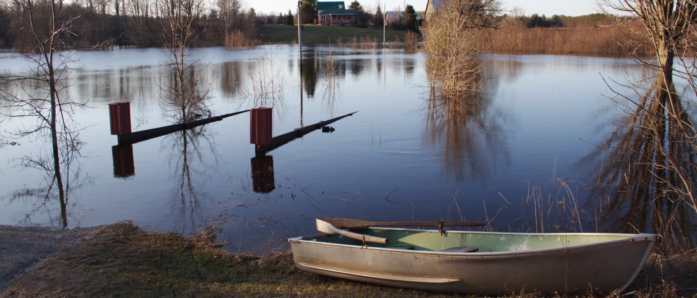
What is a flood plain?

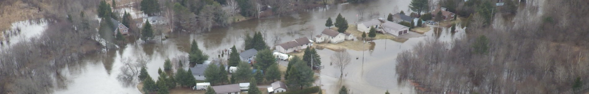
A flood plain is an area around a stream, river, or body of water where water will travel during a flood event. Collecting information about ground elevation, land use, rain and snow melt, culverts and bridges, and stream profiles allows us to model what a major flood event might look like and map where the flood plain exists.graphic image of a floodplain

How is flood plain mapping useful?

At Kawartha Conservation, we use flood plain mapping to support regulations that limit existing and new development inside the flood plain to protect your personal safety and property from flood hazards. Your home may already exist inside a flood plain. Our mapping can help you determine how much of your property is at risk and decide which hazard prevention measures to take. 

Am I in a flood plain?

Flood plain mapping study areas

Bobcaygeon

Located north of the village of Bobcaygeon this creek outlets to Big Bob Channel. West of the dam this channel is separated from Big Bob Channel by a concrete barrier.

  • Bobcaygeon Tributary Flood Plain Mapping Study Technical Report
  • Bobcaygeon Tributary Flood Plain Mapping Study Flood Maps
  • Bobcaygeon Flood Plain Mapping Study Appendices

Burnt River

Burnt River drains a very large area north of Cameron Lake and flooding occurs commonly on this river.

  • Burnt River Flood Plain Mapping Study Technical Report
  • Burnt River Flood Plain Mapping Study Flood Maps
  • Burnt River Flood Plain Mapping Study Appendices

Dunsford Creek

This water course drains rural lands west of Dunsford before flowing through the village and then along and under County Road 36 before entering Emily Creek south of County Road 36.

  • Dunsford Creek Flood Plain Mapping Study Technical Report
  • Dunsford Creek Flood Plain Study Flood Maps
  • Dunsford Creek Flood Plain Mapping Study Appendices

Fenelon Falls North

Located north of the Fenelon River, this creek drains both rural and urban areas to the Fenelon River upstream of the Falls at Lock 34. This watercourse also has a large enclosed section from Francis Street to the river outlet below the falls.

  • Fenelon Falls North Tributary Flood Plain Mapping Study Technical Report
  • Fenelon Falls North Tributary Flood Plain Mapping Study Flood Maps

Fenelon Falls South

Located on the south side of Fenelon Falls this water course drains urban lands into the Fenelon River.

Mariposa Brook

The Mariposa Brook has a large watershed which primarily drains rural agricultural lands. Two large sections of the brook join immediately downstream of the village of Little Britain, and just north of Little Britain Road.

  • Mariposa Brook Flood Plain Mapping Study Technical Report
  • Mariposa Brook Flood Plain Mapping Study Flood Maps

McLarens Creek

McLarens Creek drains an area of land from Goose Lake through the Village of Cambray and outlets to Sturgeon Lake after crossing Highway 35. A small dam also exists within the village north of Cambray Road.

  • McLarens Creek Flood Plain Mapping Study Technical Report
  • McLarens Creek Flood Plain Mapping Study Flood Maps
  • McLarens Creek Flood Plain Mapping Study Technical Appendices

Omemee East Tributary

This creek drains rural lands east of Omemee and south of Highway 7 and outlets to the Omemee Mill Pond after crossing Queen Street South.

  • Omemee East Tributary Flood Plain Mapping Study Technical Report
  • Omemee East Tributary Flood Plain Mapping Study Flood Maps

Ops #1 Drain Jennings Creek

Located north and west of the Town of Lindsay, this area drains both urban and rural lands to the Scugog River.

  • Ops #1 Drain Jennings Creek Flood Plain Mapping Study Technical Report
  • Ops #1 Drain Jennings Creek Flood Plain Mapping Study Flood Maps
  • Ops #1 Drain Jennings Creek Flood Plain Mapping Study Appendices
  • Ops #1 Drain Jennings Creek Flood Plain Mapping Study Policy Document

Sinister Creek

Located northeast of the Town of Lindsay, this area drains both urban and rural lands to the Scugog River. This creek has several crossings in the Colborne Street East area of town and runs through Rivera Park before entering the Scugog River downstream of the Lindsay dam.

  • Sinister Creek Flood Plain Mapping Study Technical Report
  • Sinister Creek Flood Plain Mapping Study Flood Maps
Environmental Sciences
    • Climate Change
    • Data Requests and Maps
    • Drinking Water Source Protection
    • Flood Forecasting and Warning
    • Flood Plain Mapping
    • Lake and Environmental Management Plans
    • Lake Scugog Enhancement Project
    • Low Water and Droughts
    • Understanding your Watershed
      Toggle Section Understanding your Watershed Menu
      • Balsam Lake
      • Blackstock Creek
      • Cameron Lake
      • Cawkers Creek
      • East Cross Creek
      • Emily Creek
      • Fleetwood Creek
      • Hawkers Creek
      • Janetville Creek
      • Jennings Creek
      • Lake Scugog
      • Layton River
      • Mariposa Brook
      • Martin Creek North
      • Martin Creek South
      • McLarens Creek
      • Nogies Creek
      • Nonquon River
      • Pearns Creek
      • Pigeon Lake
      • Pigeon River
      • Rutherford Creek
      • Scugog River
      • South Lake Scugog
      • Staples River
      • Stoney Creek
      • Sturgeon Lake
    • Watershed Monitoring
    • Know Your Signs
    • Environmental Monitoring Strategy
    • Watershed Report Cards

Contact Us

Subscribe to this page
  • Report an Issue
  • Accessibility
  • Careers
  • Store
  • Contact Us

Kawartha Conservation Footer Logo

© 2020 Kawartha Conservation

  • Freedom of Information
  • Privacy Policy
  • Sitemap
  • Website Feedback

Follow Us

View our Facebook Page View our Twitter Page View our Instagram Page View our YouTube Page View our LinkedIn Page

Immigration, Refugees and Citizenship Canada logo

With the support of the Government of Canada through the Federal Economic Development Agency for Southern Ontario

Designed by eSolutionsGroup

Close Old Browser Notification
Browser Compatibility Notification
It appears you are trying to access this site using an outdated browser. As a result, parts of the site may not function properly for you. We recommend updating your browser to its most recent version at your earliest convenience.