Close Alert Banner
Skip to Content

Kawartha Conservation Logo Kawartha Conservation Print Logo

Normal
Watershed Conditions Statement
Flood Watch
Flood Warning
Normal
Level I
Level II
Level III
  • Conservation Areas

    Conservation Areas

    • Durham East Cross Forest
    • Event Calendar
    • Fleetwood Creek
    • Ken Reid
    • Off-Leash Dog Park
    • Pigeon River Headwaters
    • Report an Issue
    • Windy Ridge
    • The Talking Forest
    • Kawartha Quest
    • Spring in the Kawartha Watershed
    • Disc Golf
    View our Durham East Cross Forest page
  • Permits and Planning

    Permits and Planning

    • Apply for a Permit
    • Book a Pre-Consultation Meeting
    • Event Calendar
    • Flood Plain Mapping
    • Planning Services
    • Property Information Requests
    • Property Mapping
    • Report a Violation
    • Source Protection Notice
    • Sediment and Erosion Control
    View our Property Mapping page
  • Landowner Services

    Landowner Services

    • Erosion and Shoreline Protection
    • Event Calendar
    • Farm Management
    • Healthy Gardens
    • Community Grants
    • Landowner Grants
    • Septic Systems and Wells
    • Tree Planting
    View our Tree Planting page
  • Learn and
    Get Involved

    Learn and Get Involved

    • Birding
    • Careers and Volunteering
    • Festivals
    • Citizen Science
    • Donations
    • Kawartha Conservation Foundation
    • Learn at Home
    • Nature Camps
    • News and Events
    • Professional Development
    • Students and Teachers
    • The Talking Forest
    • Spring time in the Kawartha Watershed
    • Kawartha Quest
    View our Kawartha Conservation Foundation page
  • Environmental Sciences

    Environmental Sciences

    • Climate Change
    • Data Requests and Maps
    • Drinking Water Source Protection
    • Flood Forecasting and Warning
    • Flood Plain Mapping
    • Lake and Environmental Management Plans
    • Lake Scugog Enhancement Project
    • Low Water and Droughts
    • Understanding your Watershed
    • Watershed Monitoring
    • Know Your Signs
    • Environmental Monitoring Strategy
    • Watershed Report Cards
    View our Cameron Lake page
  • About Us

    About Us

    • Accessibility
    • Board Meeting Calendar
    • Governance
    • Careers and Volunteering
    • Contact Us
    • Donations
    • Event Calendar
    • Online Store
    • Our Partners
    • Plans and Reports
    • Report an Issue
    • Who We Are
    • Bids and Tenders
    • Connect with Us Online
    View our Careers and Volunteering page
Contact Us

Interior banner

Lake Scugog Enhancement Project

HomeEnvironmental SciencesLake Scugog Enhancement Project
  • Open new window to share this page via Facebook Facebook
  • Open new window to share this page via Twitter Twitter
  • Open new window to share this page via Pinterest Pinterest
  • Open new window to share this page via LinkedIn LinkedIn
  • Email this page Email

The Township of Scugog has issued a public notice for the completion of the Lake Scugog Enhancement Class Environmental Assessment, and may proceed with the project by April 28, 2023 at the earliest. Questions and comments may be directed to Carol Coleman of the Township of Scugog and Ian Dobrindt of GHD Limited.

Artist rendition of constructed wetland

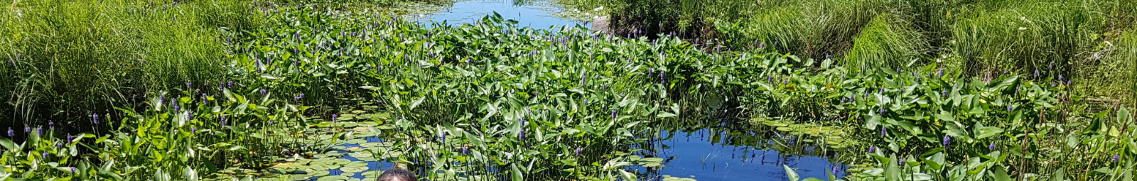
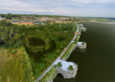
The Lake Scugog Enhancement Project (LSEP) aims to improve the water quality and recreational function of Port Perry Bay through the creation of a healthy wetland habitat, waterfront trail, and installation of stormwater management infrastructure. 

The range of benefits from this project is broad, including environmental, social, economic, tourism and recreation.

Project Objectives

Project objectives include:

  • Creating a healthy 1.4 hectare wetland habitat
  • Creating a 245m walking trail connecting four fishing platforms along the edge of the wetland
  • Enhancing stormwater treatment processes through the installation of oil and grit separators
  • Increasing recreation and tourism opportunities through a revitalized outdoor space
  • Increasing the navigational depth of Port Perry Bay to 1.8m
  • Reducing invasive aquatic plants in Port Perry Bay

Project status

Basic Impact Assessment - Parks Canada (under review)

Two Basic Impact Assessment applications were submitted to Parks Canada in 2023 and are currently under review. This review will assess:

  • Wetland construction (submitted April 2022, currently revising for updated submission March 2023)
  • Spawning shoal enhancement & installation of woody structures (submitted January 31, 2023)
 Fisheries Authorization - Fisheries and Oceans Canada

A Fisheries Authorization by Fisheries and Oceans Canada is required before project commencement. A component of this authorization is a Fisheries Offsetting Plan, which details the following activities:

  • Spawning shoal enhancement
  • Perched culvert mitigation
  • Installation of woody structures
  • Shoreline naturalization
  • Fisheries and fish habitat research

Municipal Class Environmental Assessment (Schedule B) - Ministry of Environment, Conservation & Parks (in progress)

A Municipal Class Environmental Assessment (Schedule B) undertaken by the Ministry of the Environment, Conservation & Parks began in 2018 and is currently in progress. This assessment evaluates risk and identifies potential impacts to the environment so that they can be eliminated or reduced during project implementation. 

To date, the following project requirements have been completed for the Lake Scugog Enhancement Project.

  • Review of existing conditions in Port Perry Bay including sediment quantity and quality
  • Preliminary Design Study
  • Public Open House - October 25, 2016 and December 5, 2017
  • Report to Council - November 28, 2016
  • A public notice for the completion of the Lake Scugog Enhancement Class Environmental Assessment was issued on February 28, 2023. The Township may proceed with the project by April 28, 2023 at the earliest.
Navigation Protection Program permit - Transport Canada (in progress)

A Navigation Protection Program permit is currently in progress through Transport Canada, which includes the following applications:

  • An application for the construction of a wetland and installation of woody structures in Port Perry Bay, submitted in 2019. The public commenting period has been completed, and Kawartha Conservation is in the process of completing the final design.
  • An application for the Spawning Shoal Enhancement was submitted in January 2023. The public commenting period for this application closed on March 4, 2023.

About the project

The project was initiated by the Healthy Lake Scugog Steering Committee (HLSSC), a Committee of Council to the Township of Scugog. The HLSSC is comprised of representatives from:

  • Port Perry Business Improvement Association 
  • Scugog Chamber of Commerce
  • Kawartha Conservation
  • Durham Region
  • Durham MP Erin O'Toole
  • Durham MPP Todd McCarthy
  • Ministry of Natural Resources and Forestry
  • Mississaugas of Scugog Island First Nation
  • Parks Canada / Trent-Severn Waterway
  • Scugog Lake Stewards
  • Township of Scugog Council, staff, and residents
  • Local business owners

Kawartha Conservation is the scientific and technical lead on the Lake Scugog Enhancement Project.

Township of Scugog logo         Scugog Lake Stewards logo

To learn more about the project, contact Kawartha Conservation's Water Quality Specialist, Tanner Liang, by email or by phone at 705-328-2271 ext. 228, or contact the Director of Public Works and Infrastructure Services with the Township of Scugog, Carol Coleman, by email or phone at 905-985-7346 ext.149.


This project was undertaken with the financial support of the Nature Smart Climate Solutions Fund, a Government of Canada’s Department of Environment and Climate Change program in partnership with Conservation Ontario. Other funding sources were obtained from the Greenbelt Foundation and the Mississaugas of Scugog Island First Nation.


Sponsors for the Lake Scugog Enhancement Project

Environmental Sciences
    • Climate Change
    • Data Requests and Maps
    • Drinking Water Source Protection
    • Flood Forecasting and Warning
    • Flood Plain Mapping
    • Lake and Environmental Management Plans
    • Lake Scugog Enhancement Project
    • Low Water and Droughts
    • Understanding your Watershed
      Toggle Section Understanding your Watershed Menu
      • Balsam Lake
      • Blackstock Creek
      • Cameron Lake
      • Cawkers Creek
      • East Cross Creek
      • Emily Creek
      • Fleetwood Creek
      • Hawkers Creek
      • Janetville Creek
      • Jennings Creek
      • Lake Scugog
      • Layton River
      • Mariposa Brook
      • Martin Creek North
      • Martin Creek South
      • McLarens Creek
      • Nogies Creek
      • Nonquon River
      • Pearns Creek
      • Pigeon Lake
      • Pigeon River
      • Rutherford Creek
      • Scugog River
      • South Lake Scugog
      • Staples River
      • Stoney Creek
      • Sturgeon Lake
    • Watershed Monitoring
    • Know Your Signs
    • Environmental Monitoring Strategy
    • Watershed Report Cards

Contact Us

Subscribe to this page
  • Report an Issue
  • Accessibility
  • Careers
  • Store
  • Contact Us

Kawartha Conservation Footer Logo

© 2020 Kawartha Conservation

  • Freedom of Information
  • Privacy Policy
  • Sitemap
  • Website Feedback

Follow Us

View our Facebook Page View our Twitter Page View our Instagram Page View our YouTube Page View our LinkedIn Page

Immigration, Refugees and Citizenship Canada logo

With the support of the Government of Canada through the Federal Economic Development Agency for Southern Ontario

Designed by eSolutionsGroup

Close Old Browser Notification
Browser Compatibility Notification
It appears you are trying to access this site using an outdated browser. As a result, parts of the site may not function properly for you. We recommend updating your browser to its most recent version at your earliest convenience.