Our watershed monitoring network involves collecting different types of information to assess environmental health including land, tributaries, lakes and ground water within our jurisdiction. We maintain a base level of monitoring to determine changes and watershed health over time and protect our natural assets.
Throughout our jurisdiction we monitor water quality, water quantity, aquatic health, natural heritage and weather and climate characteristics.
We monitor:
- 135 sites for water quality (chemistry including nutrients and chloride).
- 23 sites for water quantity. This includes snow courses, precipitation, water level, and streamflow monitoring locations.
- 30 sites for water temperature.
- 3 sites for weather and climate parameters (air temperature, humidity, wind speed and direction).
- 41 sites for aquatic life (focusing on streams that flow through urban areas, in partnership with the Ontario Benthos Biomonitoring Network)
We also monitor the following for our partner programs:
- 11 sites for Provincial Water Quality Monitoring Network (PWQMN).
- 13 wells for Provincial Groundwater Monitoring Network.
Find out more about the type of things we monitor across the watershed by clicking on the items of interest below:
Aquatic bugs and fish |
|
Aquatic bugs and fish are reliant upon healthy waterbodies and the land through which they flow. They contribute to functioning ecosystems upon which all life depends. Living organisms respond to changing environmental conditions, therefore, they are valuable in our monitoring programs for their role as indicators of water resource health. Available dataTo access available aquatic bug data, please visit the Ontario Benthos Biomonitoring Network database. To access available fish data, please visit the Flowing Waters Information System database. The following is a list of recent projects:
|
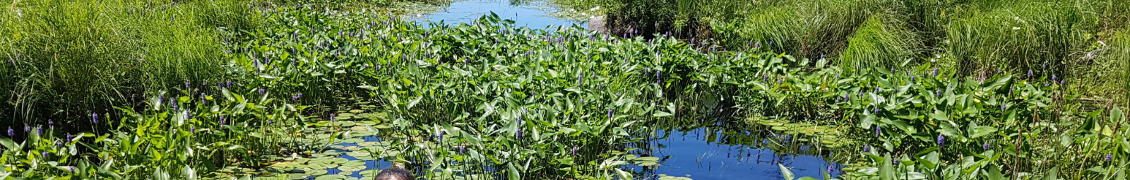
Aquatic plants |
|
Aquatic plants are of significant value to our rivers, lakes, and streams by providing habitat for aquatic life (such as fish, waterfowl, and mammals), improving water quality by absorbing nutrients, stabilizing sediments, cleansing the water column, among other important ecological and cultural functions. In certain circumstances, aquatic plants can interfere with human uses and are referred to as ‘weeds'. Aquatic plants typically thrive in shallow areas that are nutrient-rich with soft substrates. Types of aquatic plantsThe five main types of aquatic plants in the Kawartha Lakes include:
These useful booklets on aquatic plants and algae, will help you better understand, identify, and manage aquatic plants and weeds in the Kawartha Lakes. The Kawartha Lakes water management study (chapter 4, page 69) provides a historical perspective on aquatic plants within the Kawartha Lakes. |
Water quality |
|
We monitor eleven sites across our jurisdiction and perform sample collection events eight times a year. Approximately 40 parameters are analyzed (physical and chemical, including metals). Water quality is assessed by comparing the results with the Provincial Water Quality Objectives (PWQOs) for each parameter. Information is shared with municipalities, other water managers and assist in water management decisions. The Provincial Water Quality Monitoring Network (PWQMN) collects surface water quality information from rivers and streams at locations throughout Ontario PWQMN database. Over 390 locations are currently being monitored, with historical data for more than 2,000 locations dating back to 1964. |
Groundwater |
|
We monitor groundwater in thirteen wells that are located at ten sites across the watershed. To view locations and access additional details for each well, click the button below and select each well location represented on the map. These wells are part of the Provincial Groundwater Monitoring Network (PGMN). The PGMN is a partnership program with the Ministry of the Environment, Conservation and Parks to collect groundwater level and quality information across southern Ontario. There are more than 450 wells in the network. Monitoring equipment installed in wells measures and records water levels hourly. Water quality is sampled every year in the fall. You can find collected water level and water chemistry data at the provincial information system. Groundwater monitoring helps us to track changes in groundwater quantity and quality over time, identify problems and develop effective solutions. It serves as an early warning for changes in water levels caused by climate or in response to human activities such as water takings. It is also an early warning system for changes in water quality and supports sound land use planning decisions. |
Streamflow |
|
There are nine stations on rivers where we monitor water levels and flow. Five of those stations have remote access capability. You can see the latest water level readings and historical data for those stations by visiting Water Survey of Canada. Lake water levels are observed at four gauges within our watershed at the stations that are operated by the Trent-Severn Waterway (TSW). Daily water levels for the Kawartha Lakes are available from the TSW Water Management InfoNet. What results are we seeing?Local rivers and creeks flow in a natural pattern that is typical for southern Ontario. The highest water levels are observed in springtime (March-April) in response to melting snow that is sometimes increased by rains. Rain-on-snow events are the main reason for the highest water levels in our rivers and might cause flooding. View our Flood Forecasting and Warnings for more information. In summertime, it is common to see low water levels during periods of limited precipitation. Water levels are also low during winter when precipitation falls as snow and accumulates into a snowpack. If an occasional thaw melts snow, we see a spike in water levels. Water levels in Kawartha Lakes are highly regulated by the Trent-Severn Waterway. For more information please visit the Trent-Severn Waterway National Historic Site. |
Climate |
|
We monitor weather and climate parameters around the watershed including precipitation, air temperature, humidity, wind speed and direction. View climate monitoring locations Precipitation monitoring consists of the following:
Air temperature is measured in three locations, humidity in two, wind direction and speed in one. This data helps us in variety of programs and projects, including flood forecasting and warning, climate change, water quality and aquatic research. |
Land Use |
|
We monitor Land Use throughout the Kawartha Conservation Watershed by conducting Ecological Land Classification (ELC) through on screen digitization of Aerial Imagery. This imagery is collected every 5 years for our entire watershed through the South Central Ontario Orthophotography Project (SCOOP). Imagery is also collected by the Regional Municipality of Durham annually. ELC Is updated whenever new imagery is made available to produce the best, most accurate representation of the land and to make assessments accordingly. Tracking Land Use changes every 5 years is a key recommendation in our Environmental Monitoring Strategy (2022-2023). ELC is a mapping tool that identifies and describes areas of similar enduring physical attributes on the landscape. Areas are categized by a general land use classification such as Agriculture, Development, Forest, Wetland, Meadow etc. Once the landscape is categorized statistical calculations can be performed to determine percentages of land use. ELC and its statistics are very important as it helps Kawartha Conservation track landscape changes over time. It also is a key component and main contributor to our Watershed Report Cards. Below is a link to a story map showcasing 65 years of Change surrounding Lake Scugog |
Precipitation |
|
We monitor precipitation throughout the Kawartha Conservation Watershed by deploying monitoring devices such as Tipping Buckets and All-Weather Stations to collect weather data including precipitation. This data is automatically collected and recorded on an hourly basis for most of our monitoring stations and we have been slowly enhancing our monitoring grid by upgrading any manual stations where applicable and adding stations where there is potential to do so. Precipitation Monitoring is vital for Flood Forecasting and Low Water. Precipitation can also be applied to Climate Change investigation to track trends and changes throughout the years, as well as vulnerability assessments in the future. Below is a link to a dashboard that will allow you to explore Kawartha Conservations Precipitation data that has been collected over the last 23 years. |